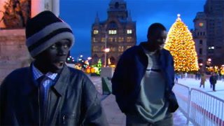
Series NatGeo: Exploring Immigration: Maps & Migration
ELA.RH.6-8.7
Common core State Standards
- ELA: English Language Arts
- RH: Reading Standards for Literacy in History/Social Studies 6-\x80\x9312
- 6-8: 6th through 8th Grades
-
7:
Integrate visual information (e.g., in charts,
graphs, photographs, videos, or maps) with other
information in print and digital texts.
Save to My Resources
PLEASE CREATE A NEW ACCOUNT OR LOG IN TO ACCESS THIS CONTENT
Enjoy your first video for free. Subscribe for unlimited access.
Have questions about subscribing?
Click Here to learn more about individual subscriptions.
Click Here to learn more about School and Institution access.
Discussion and Supporting Materials
Thought starters
- How does Ms. Daley use strategies that appeal to multiple learning styles?
- What effect does the interactive map have on student understanding?
- How does the use of media enrich this lesson?
School Details
Mayfield Woods Middle School7950 Red Barn Way
Elkridge MD 21075
Population: 725
Data Provided By:
Teachers
Karen Daley
Newest

|
4 MIN
|
5 MIN
|
5 MIN

UNCUT CLASSROOMS
| 
TCHERS' VOICE
English Language Arts

26 Comments
Aaliyah Evans Jan 5, 2022 9:49pm
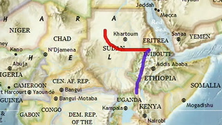
1. Mrs. Daley uses not only videos to appeal to those learners but also group discussion, and re-creating the route on a map.
2. the students where able not only visually but actively participate in the learning of these maps and historical significance.
3. the use of media brings a sense of the modern day to the classroom. Not all students are textbook learners and bringing in different forms of media keeps the class not only exciting but digestible as well.
Cameron Carey Sep 23, 2021 10:35am
.
Lauren Mullens Aug 4, 2020 2:23pm
1. She used multiple strategies that appealed to either a visual/audio style with the film and she also used a strategy for her hands-on learners as well by having them color the maps.
2. Interactive maps (depending on their complexity) can show a plethera of information in an accessible way because you have the opportunity to physically interact with that map to show what you understood.
3. I think students always enjoy media days so I personally feel that "ups" student involvement in the lesson.
Shay Centilli Jul 5, 2020 3:09pm
All the different types of ways to use a map is able to help the student be better thinkers in the classroom, also showing them the differnt types of maps and allowing them to see that sometimes just looking at a map will give you the information that is needed faster than even Google sometimes because it takes time to actually get the information from a text rather than looking at a map that has a key and will tell you the information needed. She showed the students mapping on their papers with a group, and I liked when she said that about the interactive map where if the students werent participating in the group or did not understand in the group this gives them another example and oppurtunity to be involved and ask questions or understand better for the lesson.
AUDREY Batiste Jun 19, 2020 5:34pm
Writing on the map and seeing the different textures was a good strategy and it help the students put everything in perspective. The students going to the board and tracing routes was a good example of connecting content to the location. They were learning through film, cooperative learning and the use of technology. These strategies enabled the students to learn more about an era using a map.